There are currently 7.4 billion people on earth. This number is expected to rise to 10 billion by 2080 (based on U.N. estimates). These numbers beg the question – just how many people can the planet support? And, in what regions is population growing, remaining stable, or decreasing?
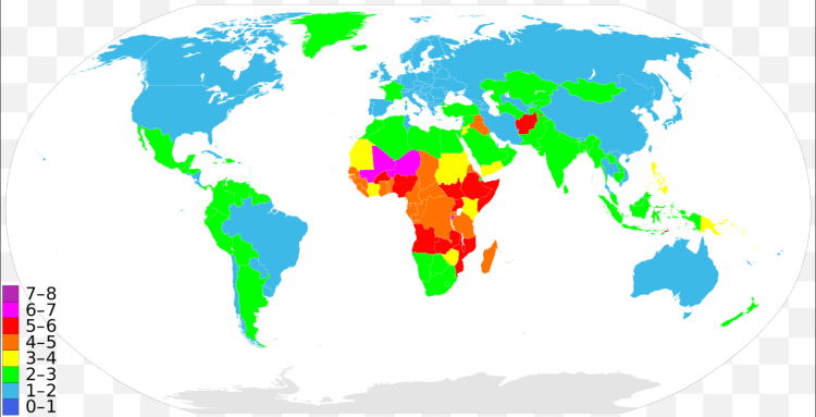
The map above colors each county by the number of children a woman is expected to have on average. Virtually all of the developed nations, such as: the US, Canada, Europe (except France), Japan, etc. average somewhere between 1-2 children per woman. This rate is actually below the replacement rate (2.1 children per women) indicating that the countries (labelled in blue above) will have decreasing populations internally over the coming decades. This does not mean, however, that the country’s population will decrease, that will depend on the number of immigrates it attracts. For example, the US and Canada attract the largest number of immigrates from across the globe which continue to bolster their population despite low birth rates internally. Conversely, a country with a low birth rate and restrictive immigration will show signs of drastic population decrease as in Japan – it has one of the lowest birth rates in the world with only 1.4 children per woman and has lost population in the past decade.
On the other end of the spectrum, Africa is exploding in population. The continent today has roughly 1 billion people. This figure is expected to double to 2 billion in just 30 years! Some countries – Niger, Mali, Burundi, Somalia – average more than 6 children per woman. It will be a time of drastic demographic change in central Africa over the next generation that may threaten the stability of the region further.
Middle income countries are mostly labeled in green in the above map indicating a healthy, moderate growth in population. For example, India (the world’s 2nd most populated country) averages 2.5 children per woman and Indonesia (the world’s 4th most populated country) averages 2.2.


 This representation is a borderless 3-dimensional world population map. The map does a great job of depicting the world’s population concentration zones in East Asia, Europe, North America, etc. What is striking is not only do oceans separate population centers from one another, but large stretches of desolate land – which are essentially operating like waterways – cutting some parts of the world off from others. For example, the Sahara separating North Africa from Sub-Sahara Africa, the Amazon in Brazil, the Himalayas between India and China, and the outback deserts make Australia almost non-existent on the map.