Above is a map of Europe (broken into sub-country subdivisions) displaying the number of patent applications per one million people. This measure can be used as an innovation proxy metric. It appears that southern Germany, Switzerland, and Southern Scandavaniva are the most innovative locations within Europe.
The World in Domain Names 2017
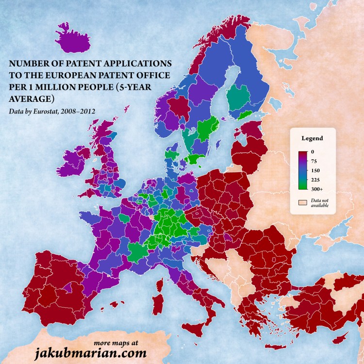
Above is a map displaying the online world, that is, each country’s size on the map represents the number of websites registered to each country code top-level domain (ccTLD). What is clear is there is a large concentration of internet activity in a small number of countries – as of June 2017 there were 302 global ccTLD, the top 10 (shown above) compose 64.8% of all ccTLD domain name registrations.
Two other things jump out from the map above:
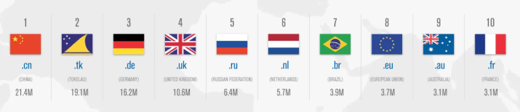
First, why is Tokelau (.tk), a New Zealand territory in the south Pacific – a county with a population of 1,499 people – second in the world with 19.1 million domain name registrations? Tokelau has specialized in web hosting by allowing any individual or business to register any number of domain names free of charge with very minimal restrictions or oversight. These policies have lead .tk domains to have a bad reputation. According to a 2011 report by the Anti-Phishing Working Group, .tk domains were involved in ~21.5% of all phishing attacks in the second half of 2010 internet-wide.
Second, why is the .us ccTLD not among the world’s largest? The United States is such an internet world power that most of its the first websites were already registered and growing their brand on Generic top-level domains (gTLD) before ccTLD domains were developed and extended for country-specific use. Americans are more familiar with gTLDs such as: .com, .org, .net, .info, .gov, .edu, and .mil – and have been low to transfer to the ccTLD .us. To have a more accurate picture of the internet world map – as of 2017, across all gTLDs, there were 331.0 million registered domains and only considering .com, .net, .org, and .info (the top 4 gTLDs combined) there are 160.6 million registered domains. Compare that with .cn (China’s top domain) the second most used domain in the world with only 21.4 million. The graph below displays the top ten domains, both ccTLD and gTLD combined – the US has four of the top ten in the world (all gTLD).
Working Class Affordability 2017
The above map was created on howmuch.net (https://howmuch.net/) showing how much a working class family can save or be indebted living in various cities across the United States. The software allows you to select different criteria – such as the number of working adults in the household, how much they earn, the number of children, amount spent on food, and size of the house in square feet – the algorithm then produces a map (such as the one above) that displays where the most and least affordable places for your family to live. The size of the bubbles are a larger dark shade of red for unaffordable locations or are a larger dark shade of green for affordable locations. For example, the map above is generated for a family of four with two incomes – a home appliance repairer and a manicurist/pedicurist with a low-cost food plan living in a 1500 sq ft home. This family would need an additional $91.2K annually to afford to live in New York City or additional $83.3K to live in San Francisco. Conversely, the family could save $10.1K annually if they lived in Glendale, Arizona.
US City Commute Patterns 2008
Above is a graph displaying the percentage of people that commute by public transit on the x-axis and the percentage commuting by car on the y-axis for various cities around the United States. The size of the bubble relates the workforce population of each city. There doesn’t appear to be a relationship between the size of the city’s population and the percentage of those taking public transit, but if one looks at city density a relationship is clear. Of the top 20 cities in the US by population, the highest density in order are: New York City, San Francisco, Boston, Chicago, Miami, Philadephia, and Washington DC. With exception of Miami (commute data not listed), all of top 6 highest density cities also have the highest fraction of their workforce commuting by public transit.
BRIC Comparison
Above is a comparison of GDP per capita (nominal) figures for BRIC countries – that is, Brazil, Russia, India, and China. The data displayed ranges from 1980 through 2016. A few things stand out, both Brazil and Russia’s economies were overvalued post-2007 financial crisis, driven by high oil prices that have regressed back to the mean and inflated currently values. China economy has leveled off in recent years and India is still much poorer than the other three BRIC economies, yet show promise moving forward.
European Union Unemployment Rate 2017
Above is a map displaying the unemployment rate for European Union member states as of May 2017. What sticks out is the slow economic recovery for the southern European states post-financial crisis, such as: Greece (with an unemployment rate of) 22.5%, Spain 17.5%, Itlay 11.3%, and Croatia 10.7%. Contrast this with the unemployment rate in the United States during the same period of 4.3%. The EU average unemployment rate stands at 7.8%, nearly twice as high of the US! An economic analysis of labor policies in most EU countries leads to this result as there is less fixability in the labor force among other factors. Despite this performance for the European Union as a whole, some countries are performing above average and are on par with the US in employment rate such as: Germany, Austria, Czech Republic, UK, Poland, and others.
Pangaea with Borders
Above is a map display what Pangaea would look like with modern day political borders overlayed. It appears that the India/Tibet sub-continent traveled the longest distance to its current location, also explaining the highest mountain range in the world – the Himalayas.
US Rivers by Flow
Above is a map showing the average flow in cubic feet per second for the major rivers in the United States. What is clear is how much water flows through the Mississippi River, especially after the Missouri and Ohio Rivers add to it. Staying with the rivers theme, below is a map displaying the major US rivers as if they were a subway map. Transit along these routes was common before railroads were laid coast-to-coast across the US.
United States Population Map
As of 2017, the United States population stands at 324 million – the third largest country in the world by population behind India and China. The population ranges across the nation from state to state, from a high of 39 million in California to a low of 585 thousand in Wyoming. The map above distorts each state’s normal area to display its relative population size. In order words, California population represents 12% of the US total and thus takes up 12% of the map, Texas 8.6%, Florida 6.3%, and so on until Wyoming with 0.18%. The states are color coded by groups of ten with the largest ten in red, the next ten in orange, then yellow, light green, and dark green. California and Texas represent 1/5th of US population and the top 5 states make up 37%. The map below is of the United States as normally displayed, with each state relative to it area.
World Map 1957
Above is a map of the world in 1957 with highlights displaying various country alliances – NATO/Western allies in Purple/Light Purple, USSR/Communist countries in Orange/Light Orange, and Muslum countries in Green. The map does a great job displaying the encirclement of allies the US had surrounding the USSR, known as the US’s strategy of containment (seeking to prevent the spread of communism to other countries).